Welcome to my trail running site. I enjoy being on the trail where I can take in nature and clear my mind. I prefer running in the mountains, but anywhere rural will do. In years past, I have completed four 100 mile trail races and many other ultramarathons. I spend countless hours running in the Franklin Mountains and the surrounding desert in far West Texas, which I call my church. My little Mexican hairless dog, Taz tags along sometimes. I am slowing down in my old age and am mostly running 50K trail races these days.
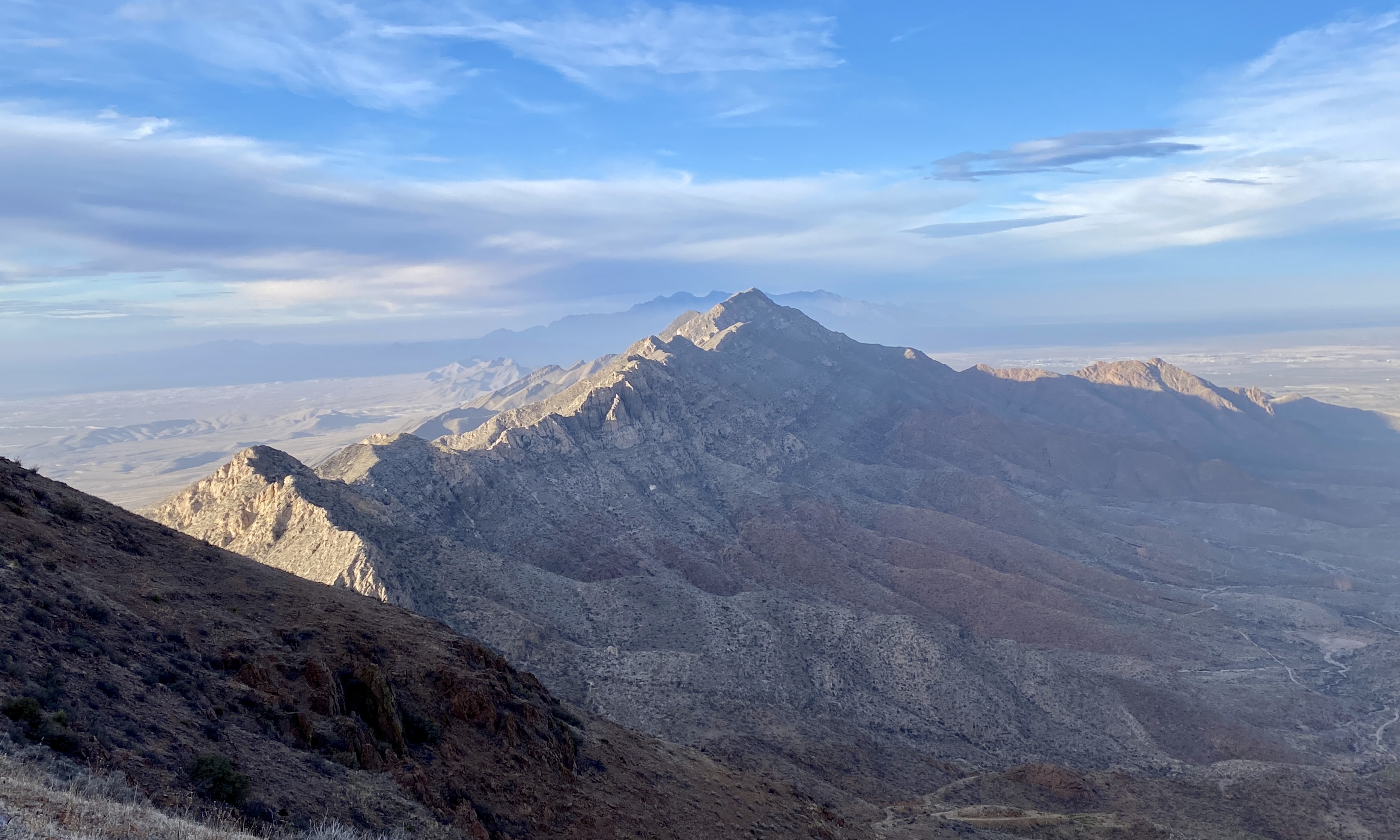
I ran the Franklin Mountains 55K Trail Run this past weekend in the state park in El Paso, TX put on by Human Potential Running Series. It had been several years since I ran this course which circumambulates the Franklin Mountain Range with a climb to the highest point —N. Franklin Peak (elev. 7192’). The trail is rugged and gnarly with plenty of rocks to keep you on your toes (literally). The route is lined with jagged, prickly and pointy vegetation, but at least the rattlesnakes are mostly dormant this time of year…MOSTLY. The course winds up and down many steep hills, with some narrow trails with precipitous drop-offs. In other words, my main goal in attempting this race is simply to, NOT DIE!
I took this pic of a mostly dormant rattlesnake by the wildlife underpass a few years ago
I have an advantage running here, in one of the largest urban wilderness parks in the US, because I train here in the Franklins almost everyday and have finished the 100K three times which is two laps around this ridiculously difficult course! This run should have felt like a stroll in the park, but it was far from it. I studied the course map since the direction and order of trails was a bit different than I had done in the past and I didn’t want to screw up and get lost.
The aztec caves
In discussing the map with some friends at the race start, I discovered my first error. We aren’t going to the Aztec Caves, they said. We always climb the steep trail up to the caves and then scramble above them to cut over to Mundy’s Gap which is roughly what the map showed. Anyway, just before the race start, the race director gave the proverbial last minute instructions to the runners, “1. Don’t be a jerk, 2. Don’t die and most importantly, have fun!”, he said. “Any last minute questions?” Well, I decided to ask, “Are we going to the caves?” He said, "No there’s another trail that doesn’t include the scramble section that you’ve done in year’s past.” I was still a bit confused, but knew I would just follow the other runners and course flagging.
Here is a visual of the course. 12 hours of running reduced to 40 seconds:
After the short briefing, we took off from the pavilion start area and started towards the caves, but instead of the usual trail, we took a new one that I had never been on. Nevertheless, we were still climbing upwards towards the caves. Pretty soon, after much strenuous grinding, I could see runners passing by the first cave. Wait, I thought we weren’t going to the caves! I kept going for a while longer and then saw runners climbing through a dry gully skirting around the higher cave. In no time, I was passing directly in front of the first cave and then went down some high log stairs to pick up the steep gully. I had only gone one mile, and my legs were already burning and my heart thumping like a drum inside my chest.
Photo from previous race
I guess my definition of going to the caves was different than the others’ definition of going to the caves. Never mind; it’s all good and we still took the high trail, above the caves with precipitous drops where death is virtually imminent. Anyway, I took my time on this part and eventually made it to Mundy’s Gap where I began the steep run down.
Runners climbing over to Mundy's Gap
I bumped into one of the old timers that frequent this trail and said, “ONLY 34 MORE MILES TO GO!” He chuckled and wished me luck. Then I thought to myself, CRAP! I have 34 more miles to go! I made it down safely and then ran a loop along the Lower Sunset Trail back to the start area (pavilion) where I filled my water bottles. The next part was Schaeffer Shuffle, a steep rocky ridge with high steps of rock. I wasn’t paying attention while climbing up the scarp while using my trekking poles and accidentally stuck my head and arm into a prickly pear cactus that was hanging from above. I had thorns in my hat and sleeves so had to stop to pull them out. I crossed the top of a ridge and negotiated the horribly steep slippery descent while only losing my footing several times with a few minor skids.
The next section was flat and somewhat boring, but I made good time. I ran in and out of several arroyos and dry washes and then reached the West Aid station, around mile 15, where I filled up again. I was pretty tired so walked up the long dirt road and slogged up the many switchbacks to the Northern Pass. The climb was tough and I could really feel my age, but I just kept putting one foot in front of the other.
Once at the top, I had a great view of the vast desert floor below spreading out for miles; a long dirt road to nowhere snaking out of view. It was windy, cloudy and chilly up there which made my spirits slump. I ran a curvy trail around Hitt Canyon, where eons of monsoon rains have cut a deep gash through the desert. I ate some snacks and mandarins to try to boost my mood and energy. This trail is deceivingly difficult for reasons unknown to me. This area of the park is extremely remote and you can feel very alone where your mind plays tricks on you; like you’ve entered a wrinkle in spacetime where everything seems to stand still.
Nevertheless, I eventually reached the base of Newman’s Trail where a new warning sign was recently put in place. “STAY SAFE — STAY ON THE TRAIL” “Potentially Dangerous Munitions May Be Encountered In Off-Trail Areas” Did I mention that I was probably going to die in this race?
Some areas in the Franklin Mountains were formerly used as Army live fire ranges and UXOs are sometimes found. Mostly in the Castner Range, though, which is SE from this area. Castner Range was designated a national monument last year, by President Biden so we may have some new trails in the future once all the UXOs are cleared. I continued on my way making sure to stay on the trail. My energy level picked up and the climb up Newman’s wasn’t as bad as I had anticipated. I was slowly nearing civilization.
Northern end of the park where time stands still
I made it to the Bowen Roundhouse aid station at about mile 23 and then ran along a smooth sandy trail to the old tin mines and base of N. Franklin Peak at mile 26. It was late afternoon by this point and the wind had died down and the sun felt welcoming on my body. I was excited to get the climb over with so I pulled out my trekking poles and started the long upward grind. The first part wasn’t too steep and I felt pretty good having caught a second wind.
In about an hour I reached the turn for the N. Franklin Peak Trail which is an out-and-back segment to the top of the mountain. My legs felt like lead and my heart was working overtime so I had to stop frequently to lean on my poles to catch my breath. I climb this mountain almost every weekend, but not on legs that have gone almost 30 miles! It’s usually a breeze, but not on this day. The last mile was especially taxing, but I was in good company as many others were struggling as well. After much effort, I slogged my way the final steps to the peak, having gone a mere four miles, from bottom to top, in two hours forty five minutes.
The sun was low in the sky casting its rays on the jagged mountain range outlining the peaks in a silver hue. I tagged the antenna base that sits on the mountaintop and grabbed a summit wrist band to prove I had made it. I enjoyed the view for a few minutes snapping some pictures and then headed back down.
Going down is equally as slow because the terrain is so rugged. Jagged rocks make the footing precarious and there are plenty of nearly perpendicular rock outcrops that you have to negotiate. Several times my shoe slipped causing a sharp rock to stab the side of my foot. OUCH! By this point, I was out of water and still had several more miles to go before the next aid.
Approaching the summit
I made it back down and hiked the short climb up to Mundy’s Gap while the sun slipped below the horizon. The next stretch was a real bitch because the trail is steep, narrow and slippery with many game trails crossing the slopes willy-nilly. It was almost dark making it difficult to see the path and course markings. There were runners in front of me with their headlights beaming so I could sort of see which direction to go. I spotted the giant cottonwood tree below, a sentinel who’s been watching over the Cotton Wood Spring here for decades. When it was almost completely dark, I reached the bench under the tree where I stopped to pull out my headlamp.
Now I could see…sort of. I climbed down some very high log steps where an enormous sun bleached limb; part of the tree actually, had fallen in high winds blocking the route. I had to kneel down to crawl under it and then my 60 year old body had trouble standing back up again. At this point I wasn’t sure which way to go, because there are two ways down and I didn’t bother to watch the race briefing video because I know these trails better than the back of my hand.
My running buddies, Angel and Isela gettin'er done!
I started down the scree slope towards an old rusty stock tank because my brain said, this is the easier and quicker way down. Wishful thinking! I didn’t see any course flagging though, and became nervous. Of course, I didn’t want to cut the course and get disqualified, so I decided to climb back up to the last pink flagging. Then I saw more markers and realized we had to cross the scree field to High Newman Trail. I don’t like this trail because it’s narrow with a sharp drop-off and lots of rocky tripping hazards where a minor misstep will send you tumbling to the bottom of a jagged rock pile! I especially don’t like this trail in the dark, I do not like it in the rain or on a train, or in the wind or when I’ve sinned. I DO NOT LIKE IT SAM I AM!
I told you I was going to die, right! Well, at least I had my trusty trekking poles; my security blanky to help keep me in an upright position. I traversed the scree slope and climbed up onto the trail and ran for a while. I gingerly negotiated several piles of shifting rocks of every geometric shape, using my poles to keep my balance on the precarious obstacle. Once across, I ran for a while where suddenly my toe caught a protruding rock and hurled me forward where I barely kept myself from tumbling off the edge. After this shock, I took my time, carefully reaching the last aid station at the bottom of the trail.
Northeast El Paso
I ran on the paved park road, picked up the very technical Upper Sunset Trail and power hiked up a steep rock outcrop lined with pointy shin dagger (lechuguilla). I climbed high stairs of crumbly rocks using my poles to push myself up. At the top, I ran when I could but there isn’t much of a trail here, just a rocky ridge with all manner of rocks to stub your toes on. After over 12 hours of running, I ran the final slope into the finish line. I was exhausted, but still alive. I guess I cheated death once more and had a grand running adventure in the Promised Land to boot!
The Franklin Mountains Trail Run is a great event that includes a full weekend of runs including the King and Queen of the Mountain on Friday; 50 mile, 55K and 30K on Saturday and the 5K, 10K and Half Marathon on Sunday. Pick your poison carefully and try not to die, OK!
Recently I ran the Mt Taylor 50K in Grants, NM, which was my fourth finish on this sacred mountain that tops out at 11,300'. If you know me, then you understand that mountains, forests, deserts and rivers are my church. You could also call it your synagogue, mosque, temple or simply your happy place; It doesn't matter. Mt Taylor, known as Tsoodził (Turquoise Mountain) to the Navajo is one of four sacred mountains that mark the boundary of their nation.
According to author, Tony Hillerman's version of Navajo mythology:
First Man buried turquoise in this range, hence its symbolic blue color... the chief of the Enemy Gods, Yé'iitsoh, once resided in this peak. When the Twin War Gods (Born for Water and Monster Slayer, sons of Changing Woman) killed Yé'iitsoh, his blood spilled down the slopes and hardened into the lava flows of El Malpais in the area surrounding Grants. The mountain features as a central and meaningful location for Blessingway and Enemyway ceremonies.
This summer, I ran several times in Cloudcroft, NM including the 53K trail race. The heat was unbearable in El Paso, TX this year, so I went up to the Sacramento Mountains in New Mexico to camp, train and relax in the Lincoln National Forest. The elevation is between 8-9 thousand feet and can be 40 degrees cooler than on the desert floor.
Elk
I did a 25 mile training run in June on some parts of the race course which is mostly on the Rim trail. I combined the Rim trail and Westside Rd (Forest Rd 90) by descending Heart Attack Canyon (T235) and ascending Alamo Peak Trail (T109) to simulate the steep climb that I would experience on race day.
I ran the Jemez Mountain Trail 50K in Los Alamos, NM this past weekend, which is one of my favorite races. I keep coming back year after year to enjoy the beauty of the land and to test my mettle under the always challenging conditions. The terrain is tough, with short steep climbs in and out of deep canyons as well as a long slow grind topping out at 10,400’ elevation on the Pajarito summit. This event offers 50 mile, 50K and 15 mile courses, with staggered start times, so you can pick the level of misery you would like to experience. This year I chose the intermediate suck level.
Valle Caldera National Preserve on a cler day
This was my 9th attempt. In years past, I’ve completed five 50 milers, one 50K and have had two DNFs, one for runners being halted mid-race for a freak snow storm! I was running down the mountain in heavy cold rain while it was snowing on the peak. When I arrived at the the next aid station at the bottom, they informed us that the race was called off because some runners at the top were suffering from hypothermia and other cold related injuries.
Earlier this month, I ran the Sierra Vista Trail 50K in the Organ Mountains National Monument in Las Cruces, NM. I’ve run one of their distances from 30K-100K many times in years past. The race is directed by the Southern New Mexico Trail Alliance, a team of volunteers who build and maintain trails here.
The route skirts the western base of the mountain chain winding through prickly vegetation, numerous rocks and through arroyos and dry washes. The weather was almost perfect; not too hot, but kind of blowy in the afternoon. I was mostly alone on the trail all day and really enjoyed the quiet and solitude.
I wasn’t too fast or anything since I have been recovering from a bout of plantar fasciitis and some achilles pain, not to mention that I’m old and getting slower each year. In spite of that, I finished in 8:30. I didn’t run much last fall, but was able to scrape through the Franklin Mountains Trail half mary in January. I was signed up for the 50K, but had to drop down since I hadn’t been training very much.
Anyway, here are some pictures from the race and I have included some links from past Sierra Vista adventures at the bottom.
How can you escape the scorching summer temperatures of the Chihuahuan Desert in Far West Texas? The only way is to go straight up to gain some altitude. Therefore, you could drive a few hours east to Van Horn, TX and pay millions for a 15 minute flight on one of Jeff Bazos’ Blue Origin rocket ships. Or, go the cheaper route and drive a few hours north to the cool pines of the Sacramento Mountains in Cloudcroft, NM (8,675′). The latter has been the preferred method for El Pasoans since the days of the Alamogordo and Sacramento Mountain Railway which reached Cloudcroft in 1900. The Cloud-Climbing rail has since been dismantled, but many sections have been repurposed into hiking trails by Rails-to-Trails Conservancy. This makes Cloudcroft an excellent trail running and hiking destination.
Broad-tailed hummingbird near High Rolls, NM
Last weekend I ran the Cloudcroft Ultra 53K Trail Race put on by the good family that owns High Altitude (your favorite little outdoor store). This is the second year that I ran this low key race which is an out-and-back along the Rim Trail with a lollypop loop, including a brutal climb, I might add, before returning to the village. About 50 of us started at the local park, running the first several miles through town on mostly flat paved and dirt roads and then picked up the Rim Trail once out of the village.
Well, if you haven’t heard, New Mexico is pretty much on fire with two of the largest wildfires in the state’s history still burning. Some monsoon rains moved in a few weeks ago though, which has considerably helped the situation. The concern now is flooding, erosion and mudslides in the burn areas.
Because of this, my spring race, the Jemez Mountains 50 Miler, was cancelled this year due to forest closures. This summer, we had planned a trip to Colorado because my kid was going to music camp at the Beaver Creek Ski Resort near Vail, CO. What's really amazing though, is that my wife said I could run and hike during the day while they attended her music classes. Well, that sounded like a grand idea to me!
Beaver Creek, CO
My first worry started when we pulled up to the upscale gated luxury village that was developed by oil tycoons in the 80s. I thought to myself, there’s no way they are going to let the likes of me and my 15 year old truck into a place like this. To me, luxury accommodations are a campground with a pit toilet. Five star camping includes a public bathroom with running water. (Glamping!) Anyway, we somehow made it past the security gate and checked into our fancy place which had everything under the sun including the kitchen sink!